Best drones for mapping and surveying
Mapping work lives or dies on positioning accuracy and overlap discipline, not just camera quality: this page ranks aircraft on that basis.
Researched from published specifications and verified owner reviews · updated 2026
The short answer
For survey-grade mapping and surveying, the Autel EVO II Pro RTK V3's onboard RTK cuts positioning error to roughly a centimeter per photo, while the DJI Air 3S and Mavic 4 Pro remain capable mapping platforms when paired with ground control points and 70 to 80 percent front overlap.
For mapping and surveying work, the Autel EVO II Pro RTK V3 is the clear top pick. Onboard RTK positioning corrects each photo's location to roughly centimeter-level accuracy in the field, which is what turns a photogrammetry flight into a survey deliverable rather than a pretty orthomosaic. The DJI Mavic 4 Pro Fly More Combo remains a strong choice when RTK is not required and ground control points can carry the accuracy work instead.
Autel
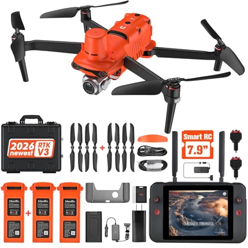
Autel EVO II Pro RTK V3
Onboard RTK, centimetre-level positioning
Onboard RTK positioning at roughly centimeter-level accuracy per photo is the difference between drone photography and drone surveying, and it cuts the ground control workload dramatically.
Prices move constantly. We earn a commission if you buy through these links, at no extra cost to you.
Every flight discussed here is commercial work under Part 107: mapping and surveying for a client, a project, or any business purpose requires a certificated remote pilot, a registered aircraft regardless of its weight, and often an airspace authorization before launch.
What actually separates a mapping-capable drone from a camera drone?
Two things a mapping job demands that casual aerial photography does not: positioning accuracy for every single photo, and a flight pattern that produces enough overlap for photogrammetry software to reconstruct the site geometrically. Any camera drone can technically fly a grid pattern, but the aircraft that actually earns the "mapping" label either carries onboard RTK positioning, like the Autel EVO II Pro RTK V3, or has a sensor and flight planning workflow good enough to make ground control points do that accuracy work reliably.
What does RTK positioning actually buy you in the field?
Real-Time Kinematic positioning corrects the aircraft's GPS location against a fixed reference signal in real time, cutting positioning error from the several meters typical of standard GPS down to roughly a centimeter for each photo. That accuracy is baked into the image metadata as it is captured, which means the resulting model starts from a much better geometric foundation before any ground control correction is applied. On the Autel EVO II Pro RTK V3, that RTK data comes from the aircraft itself rather than a separate ground station workflow, which simplifies field setup considerably compared to older RTK systems that required a dedicated base station on every job.
RTK reduces the ground control point workload, but it rarely eliminates it entirely. A set of surveyed Ground control point targets (10 pack) placed and measured across the site still provides an independent accuracy check against base station error or drift, and many client and regulatory deliverables specifically require verified ground control regardless of how the aerial data was positioned. Budget for a handful of control points even on an RTK flight, just fewer than you would need without RTK.
How much overlap and what ground sample distance do I actually need?
Front overlap of 70 to 80 percent along each flight line and side overlap of 60 to 70 percent between adjacent lines is the standard photogrammetry range. Below that range, weak stitching points and outright gaps become a real risk, especially over featureless surfaces like a uniform grass field, sand or a flat, uniformly colored roof where the software has little texture to match between overlapping frames. Complex terrain and low-texture surfaces both push toward the higher end of both overlap ranges.
Ground sample distance, or GSD, is the real-world size that one pixel represents on the ground, and it is the specification most clients and regulators actually ask for. It is calculated as sensor width in millimeters, multiplied by altitude in meters, multiplied by 100, divided by the product of focal length in millimeters and image width in pixels, giving centimeters per pixel. Flying lower produces a finer GSD at the cost of covering less area per flight and needing more photos and more overlap discipline to cover the same total site. Our ground sample distance calculator and the GSD versus altitude reference chart both turn this formula into a number for your specific aircraft and altitude rather than a rule of thumb.
How does flight altitude change by the type of site I am mapping?
Agricultural mapping, such as a crop health survey across a large field, generally tolerates a coarser ground sample distance and can fly higher, which covers more acreage per battery and per flight day. A construction site or a stockpile volumetric survey usually needs a much finer GSD to resolve individual material piles and grading detail accurately, which means flying lower and accepting fewer acres covered per battery in exchange for a model precise enough to support a volume calculation that a client will actually rely on for billing or planning.
A roof or building facade mapping job sits at a different extreme again, often requiring oblique, angled imagery in addition to the standard nadir, straight-down passes, since a purely top-down dataset misses vertical surfaces and overhangs entirely. Planning the right altitude and camera angle combination for the specific deliverable, rather than defaulting to one standard mission profile for every job, is the difference between a dataset that actually answers the client's question and one that technically covers the area but misses the detail that mattered.
How do I plan power and data for a full mapping day?
Mapping missions run longer than typical aerial photography, both in flight time per battery and total site coverage across multiple flights, which puts real pressure on storage and field power. A SanDisk Extreme 512 GB microSD 512 GB card avoids swapping cards mid-mission, which matters because a card swap on a large site means landing, changing cards and re-verifying you have not missed a section, rather than a quick pause. A Jackery Explorer 300 portable power station portable power station recharges a full battery set roughly twice over at a remote site with no wall power, and it doubles as power for a laptop doing on-site data verification before you leave the site and discover a gap the next day.
What deliverables does a mapping flight actually produce?
Raw drone photos are only the input. Photogrammetry software processes the overlapping image set into several distinct output products, and knowing which one a client actually needs shapes how you fly the mission before you ever take off. An orthomosaic is a single, geometrically corrected image of the entire site stitched from every photo, with distortion and perspective removed so that measurements taken directly from the image are accurate, which is the most common deliverable for agricultural and general site mapping. A digital elevation model records the height of the ground surface across the site as a grid of values, which is what a drainage study or a cut and fill earthworks calculation actually needs rather than a flat image.
A dense 3D point cloud goes a step further, reconstructing the site as millions of individually positioned points in three dimensions, which supports volumetric measurements of stockpiles, excavation progress or fill material, a use case common on construction and mining sites. Some processing pipelines also generate a textured 3D mesh, useful for visual presentations and client walkthroughs where an orthomosaic's flat top-down view does not communicate terrain relief well. The Autel EVO II Pro RTK V3's RTK positioning improves the geometric accuracy of every one of these outputs, since the underlying image positions are more accurate before processing even begins, which matters most for the elevation model and point cloud outputs where vertical accuracy is the harder problem to solve after the fact.
Matching the deliverable to the mission plan matters because each output has different overlap and altitude sensitivities. A simple orthomosaic tolerates the standard 70 to 80 percent front and 60 to 70 percent side overlap comfortably. A high-accuracy point cloud for volumetric work often benefits from higher overlap and a lower flight altitude to increase point density, which trades flight time and battery count for model resolution. Confirm which deliverable your client actually needs before finalizing a flight plan, since re-flying a site because the first pass was optimized for the wrong output wastes far more time than planning it correctly once.
The three tiers, from a learning project to survey-grade deliverables
Match the aircraft to the accuracy your deliverable actually requires
RTK is a real accuracy jump, not a marketing feature, but it is only worth paying for when the deliverable requires that accuracy.

DJI
DJI Air 3S (RC-N3)
1-inch main plus 70 mm tele, 45 min rated
Learning photogrammetry fundamentals on small sites, using ground control points instead of onboard RTK to hit reasonable accuracy.
Two usable focal lengths on one aircraft, a one-inch main sensor and a 45 minute rated pack. The value centre of the whole camera-drone market and the aircraft most working shooters actually own.

DJI
DJI Mavic 4 Pro Fly More Combo
Tri-camera flagship, 100 MP class main sensor
Larger mapping areas and better sensor quality for orthomosaics that still rely on ground control rather than survey-grade positioning.
Three focal lengths, the largest sensor in the folding class and the colour depth that survives a real grade. Buy it when a client is paying for the image, not because it is the newest thing.
Autel
Autel EVO II Pro RTK V3
Onboard RTK, centimetre-level positioning
Operators billing survey-grade deliverables, where onboard centimeter-level positioning replaces most of the ground control point workload.
Onboard RTK positioning, which is what turns a mapping flight into a survey deliverable. This is the line where drone photography becomes drone surveying.
Prices are approximate and change constantly. Links are affiliate links: we earn a commission if you buy, at no extra cost to you.
The expert tier, the Autel EVO II Pro RTK V3, is not the right purchase for a hobbyist mapping a community garden, a one-off personal project, or any job where the client is not actually asking for survey-grade accuracy. At $2,999 it costs meaningfully more than the DJI Mavic 4 Pro Fly More Combo, and that premium only pays for itself when a deliverable specifically requires centimeter-level accuracy or when the reduced ground control point workload saves enough field time to justify the purchase on its own. For learning photogrammetry fundamentals or occasional mapping work, ground control points and a standard camera drone remain a completely legitimate approach.
How do we evaluate mapping drones without flying a mission ourselves?
We do not fly review units, and mapping accuracy claims are exactly the kind of specification where that distinction matters most. RTK accuracy figures, sensor specifications and battery ratings come from manufacturer documentation and published engineering material. How each aircraft actually behaves on a real mapping job, including how RTK holds up in obstructed sky view or how consistently a grid mission completes without a manual restart, comes from verified owner reviews and published field reports from surveyors and mapping professionals who fly these missions for a living. Where those field reports disagree with a manufacturer's stated specification, we say so.
What should I check before buying a drone for mapping work?
Confirm what accuracy standard your deliverable actually requires before choosing between RTK and a ground-control-point workflow, since paying for RTK you do not need wastes budget that could go toward more ground control points or additional flight time instead. Plan your mission properly before flying: our how to plan a mapping mission guide and the mapping mission calculator turn site area, desired GSD and overlap settings into an actual flight plan with line count and battery requirements. Once you have imagery in hand, the photogrammetry workflow guide covers the processing side, and what Part 107 actually lets you do confirms the certification and airspace requirements for the commercial flight itself.
Mapping aircraft comparison
| Aircraft | Positioning | Sensor | Typical GCPs needed | Rated endurance | Price |
|---|---|---|---|---|---|
| DJI Air 3S (RC-N3) | Standard GPS | 1-inch main + tele | 5 to 9 per site | 45 min rated | $989 |
| DJI Mavic 4 Pro Fly More Combo | Standard GPS | 1-inch class main, tri-cam | 5 to 9 per site | 51 min class rated | $2,899 combo |
| Autel EVO II Pro RTK V3 | Onboard RTK, centimeter-level | Enterprise mapping sensor | 2 to 4 per site | 40 min class rated | $2,999 |
GCP counts above are typical planning ranges, not fixed rules; actual requirements scale with site size, terrain complexity and the accuracy your client or regulator specifies. Cross-check your specific overlap and altitude plan against the mapping mission calculator linked above before a large or unfamiliar site, and confirm your certification status against your Part 107 privileges before you accept commercial mapping work.
Questions people ask
+ What does RTK actually do for a mapping drone, in plain terms?
Real-Time Kinematic positioning corrects the aircraft's GPS location against a fixed reference signal, cutting positioning error from several meters down to roughly a centimeter for each photo captured. That means every image in the dataset already carries accurate geographic coordinates, which reduces how many surveyed ground control points you need to place and measure by hand to produce a deliverable that meets survey-grade accuracy requirements.
+ Do I need ground control points if my drone has onboard RTK?
Fewer, but usually not zero. RTK dramatically improves the accuracy of the aircraft's own position at the moment each photo is captured, but a handful of surveyed ground control points still provides an independent check against drift or a base station error, and many client and regulatory deliverables specifically require verified ground control regardless of how the imagery was positioned. Treat RTK as reducing your ground control workload, not eliminating the practice.
+ How much overlap do I need between photos for a usable photogrammetry model?
The common standard is 70 to 80 percent front overlap along the flight line and 60 to 70 percent side overlap between adjacent lines. Overlap below that range risks gaps or weak stitching points in the resulting model, especially over featureless surfaces like uniform grass, sand or a flat roof. Complex terrain, tall structures or low-texture surfaces often benefit from overlap at the higher end of both ranges.
+ What is ground sample distance and why does every mapping page mention it?
Ground sample distance, or GSD, is the real-world size that one pixel in your image represents on the ground, commonly expressed in centimeters per pixel. It is calculated from sensor width, flight altitude, focal length and image width in pixels. GSD directly controls how much real-world detail your map or model can resolve, and it is the specification a client or regulator will actually ask for when defining accuracy requirements for a deliverable.
+ Can I use a standard camera drone like the Air 3S or Mavic 4 Pro for mapping without RTK?
Yes, and it is how most photogrammetry work has been done historically. Fly a planned grid mission with proper front and side overlap, place and survey a set of ground control points across the site, and process the imagery through photogrammetry software that uses those points to correct positioning. This produces accurate results for most mapping needs; it just requires more fieldwork per project than an RTK-equipped aircraft does.
+ How much area can one battery realistically cover on a mapping flight?
It depends heavily on altitude, overlap settings and aircraft efficiency, but as a rough planning figure, a prosumer camera drone flying a grid at 250 to 300 feet with standard overlap covers somewhere between 50 and 150 acres per battery, with larger sites at higher altitude covering more area per flight at the cost of coarser ground sample distance. Our mapping mission calculator converts your specific altitude, overlap and area into a real flight and battery count.