Ground sample distance chart
Centimetres per pixel at every altitude, for the camera classes people actually fly.
Researched from published specifications and verified owner reviews · updated 2026
The short answer
Ground sample distance is the real-world size of one pixel on the ground and it scales linearly with altitude. A 20 megapixel one-inch sensor at a 24 mm equivalent focal length gives roughly 2.7 cm per pixel at 100 metres, about 1.6 cm at 60 metres and about 3.3 cm at 120 metres. It depends on pixel count and field of view rather than sensor size, and it is a resolution figure rather than an accuracy figure.
Ground sample distance is the number that turns a photograph into a measurement. It states how much ground one pixel covers, which sets the smallest feature that can be resolved and decides whether a mapping deliverable meets its specification. It is also linear in altitude, which makes it unusually easy to plan around once you have a figure for your camera.
Autel
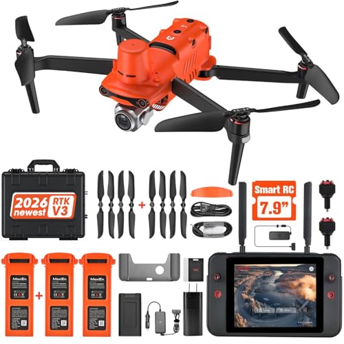
Autel EVO II Pro RTK V3
Onboard RTK, centimetre-level positioning
Ground sample distance tells you what is visible. It says nothing about whether a point in the model sits where it claims to on the earth. Onboard RTK positioning is what converts a detailed photogrammetry model into a survey deliverable you can attach an accuracy statement to, and no amount of extra resolution substitutes for it.
Prices move constantly. We earn a commission if you buy through these links, at no extra cost to you.
The formula
Ground sample distance in centimetres per pixel equals sensor width in millimetres, multiplied by altitude in metres, divided by the product of focal length in millimetres and image width in pixels, multiplied by one hundred. Every term except altitude is on the camera specification sheet.
Because altitude is the only variable, the result scales linearly: doubling altitude doubles the ground sample distance, and halving it halves it. That linearity is what makes the table below useful, since you can interpolate anywhere between rows without error. Work a specific camera on the ground sample distance calculator, which also runs the calculation backwards from a required resolution to a maximum altitude.
Ground sample distance by altitude
Four representative camera classes, all at roughly a 24 mm equivalent field of view, which is the standard wide lens on consumer camera drones. Figures are centimetres per pixel.
| Altitude | 1/1.3 in, 12 MP | 1 in, 20 MP | 4/3 in, 20 MP | 1/1.3 in, 48 MP |
|---|---|---|---|---|
| 30 m (about 100 ft) | 1.07 | 0.82 | 0.80 | 0.53 |
| 40 m (about 130 ft) | 1.42 | 1.10 | 1.07 | 0.71 |
| 50 m (about 165 ft) | 1.78 | 1.37 | 1.33 | 0.89 |
| 60 m (about 200 ft) | 2.13 | 1.64 | 1.60 | 1.07 |
| 80 m (about 260 ft) | 2.84 | 2.19 | 2.13 | 1.42 |
| 100 m (about 330 ft) | 3.55 | 2.74 | 2.67 | 1.78 |
| 120 m (about 394 ft) | 4.26 | 3.29 | 3.20 | 2.13 |
Note the two 20 megapixel columns. A one-inch sensor and a four-thirds sensor at the same equivalent focal length and the same pixel count give almost identical ground sample distance. The larger sensor buys dynamic range, shadow detail and low-light performance, and it does not buy resolution on the ground. That is worth knowing before paying for a larger sensor on the assumption that it maps better.
Note also the 120 metre row. Four hundred feet above ground level is the ceiling for both recreational and Part 107 flying in the United States, and 120 metres is just under it, so that row is the practical maximum altitude for almost all drone mapping. The rule is on the rules quick reference.
What resolution each job needs
| Job | Typical requirement | Altitude on a 20 MP one-inch camera |
|---|---|---|
| Site overview and progress documentation | 4 to 5 cm/px | Around 120 m, at the ceiling |
| Stockpile volumetrics | 3 to 4 cm/px | Around 100 to 120 m |
| General topographic mapping | 2 to 3 cm/px | Around 70 to 100 m |
| Detailed site plan | 1.5 to 2 cm/px | Around 55 to 70 m |
| Roof and facade inspection | 0.5 to 1 cm/px | Around 20 to 35 m |
| Crack and defect detail | Better than 0.5 cm/px | Under 20 m, or a longer lens |
Always confirm the required figure with the client before flying rather than after. A deliverable that misses a specified ground sample distance has to be re-flown entirely, because there is no way to add resolution in processing.
Why flying lower is not free
Image count scales with the inverse square of altitude, because halving the height halves the footprint in both dimensions. Fly at 60 metres instead of 120 and you need roughly four times as many images to cover the same area at the same overlap. That multiplies flight time, battery count, card capacity and processing time, all at once.
| Altitude | Relative footprint per image | Relative image count for the same area |
|---|---|---|
| 120 m | Baseline | 1x |
| 85 m | About half the area | About 2x |
| 60 m | About a quarter | About 4x |
| 40 m | About one ninth | About 9x |
| 30 m | About one sixteenth | About 16x |
The planning rule that follows is simple: fly the highest altitude that meets the required ground sample distance, and no lower. Low flying also raises obstacle risk, makes overlap discipline harder because small heading errors matter more, and produces far more images for the processing software to reconcile. The whole chain from area and altitude to image count, airborne minutes and pack count is on the mapping mission planner.
Resolution is not accuracy
This distinction is worth stating in the plainest possible terms because clients conflate it constantly and it is where drone mapping contracts go wrong.
Ground sample distance is resolution. It tells you the smallest feature that can be seen in the imagery. It is a property of the camera and the altitude.
Positional accuracy is something else entirely. It tells you how closely a point in the model corresponds to its true position on the earth. It comes from the quality of the positioning during capture and from surveyed control on the ground, and a model can have 1 cm resolution while sitting a metre out of position.
Getting accuracy means RTK positioning on the aircraft and surveyed Ground control point targets (10 pack) ($70) laid and measured before the flight, plus check points held back from the processing so the result can be verified independently. The workflow is on the photogrammetry workflow and the aircraft ranking is on best drones for mapping and surveying.
Things that quietly ruin the number
Motion blur. A smeared pixel does not resolve at its theoretical size and it does not match reliably between overlapping frames. Fast shutter, moderate flight speed, and accept that mapping is the one case where the cinematic shutter rule is wrong. See the shutter speed chart.
Terrain relief. Ground sample distance is computed from height above ground, and over a slope that height changes continuously. A mission planned at a fixed altitude above the launch point delivers different resolution at the top and bottom of a hill, which is why terrain following exists.
Digital zoom and cropping. Neither adds resolution. A cropped image has the same ground sample distance over a smaller area, which is occasionally useful and never an improvement.
Wind. Higher ground speed downwind means more distance covered per shutter interval and less overlap than planned, which can leave holes in the model. Plan the grid into the wind on the long legs and check the wind margin calculator first.
Figures on this page are computed from published camera specifications using the standard ground sample distance formula. Individual cameras vary in actual sensor dimensions and effective focal length, so confirm against your own specification sheet before a job depends on the number.
Questions people ask
+ What is ground sample distance?
The real-world size of one pixel measured on the ground. A ground sample distance of 2.7 cm per pixel means each pixel in the image covers a 2.7 cm square of ground. It is the resolution figure that matters for mapping, because it sets the smallest feature that can be seen and it feeds directly into whether a deliverable meets a client specification.
+ How do I calculate GSD?
Sensor width in millimetres multiplied by flight altitude in metres, divided by focal length in millimetres multiplied by image width in pixels, then multiplied by 100 to give centimetres per pixel. Every term is on the camera specification sheet except altitude, which you choose. The relationship is linear in altitude, so doubling height doubles the ground sample distance.
+ Does a bigger sensor give better ground sample distance?
Not by itself, which surprises people. Ground sample distance depends on pixel count and field of view, so a 20 megapixel one-inch sensor and a 20 megapixel four-thirds sensor at the same equivalent focal length produce almost identical figures. The larger sensor buys dynamic range and low-light performance, not resolution on the ground.
+ Is resolution the same as accuracy?
No, and conflating them is the most expensive mistake in drone mapping. Ground sample distance tells you how small a feature is visible. Positional accuracy tells you how closely a point in the model corresponds to its true position on the earth, and that comes from RTK positioning and surveyed ground control points. A model can have excellent resolution and be a metre out of position.
+ What GSD do typical jobs need?
Broad site overviews and volumetrics are commonly fine at 3 to 5 cm per pixel. General topographic mapping usually sits around 2 to 3 cm. Detailed inspection work and anything where hairline features matter wants 1 cm or better, which means flying low and accepting a much larger image count. Always confirm the required figure with the client before flying.
+ Why not just fly as low as possible?
Because image count scales with the inverse square of altitude. Halving the altitude quadruples the number of images for the same area, which multiplies flight time, battery count, storage and processing time. Low flying also increases obstacle risk and makes overlap discipline harder. Fly the highest altitude that meets the required ground sample distance.