The commercial mapping and inspection build
A working kit for deliverables that carry an accuracy claim. Twenty items, one total, certification first.
Researched from published specifications and verified owner reviews · updated 2026
The short answer
A complete commercial mapping kit runs around $4,769, led by an RTK-equipped aircraft at about $2,999, ground control targets, all-day field power, two 512 GB cards, an SSD for on-site offload, weather instruments and a carry-on legal case. The certification comes first: commercial flight requires an FAA Part 107 remote pilot certificate.
This build starts with a book rather than an aircraft, and that ordering is deliberate. Every flight on this list is a commercial operation, which means an FAA Part 107 Remote Pilot Certificate is a prerequisite rather than a nice-to-have. The aircraft is the Autel EVO II Pro RTK V3 ($2,999), chosen because onboard RTK positioning is the line between drone photography and drone surveying.
Autel
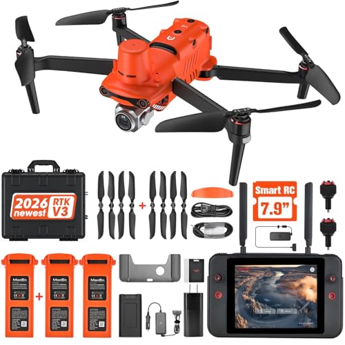
Autel EVO II Pro RTK V3
Onboard RTK, centimetre-level positioning
Onboard RTK timestamps each image against a corrected position, which is what turns a photogrammetry model into a deliverable with a defensible accuracy figure rather than a picture with good relative geometry.
Prices move constantly. We earn a commission if you buy through these links, at no extra cost to you.
Read the honest warning first: this is a harder, more expensive discipline than aerial photography, not a natural next step from it. If your work is imagery, the prosumer creator build at a third of the price will serve you better, and adding ground control targets to it covers a surprising amount of commercial mapping that does not carry a survey-grade claim.
Tier 3 of 3, working kit
The commercial mapping build
Certification, before any of the hardware
subtotal $64This is the only group on the page that is not optional and not substitutable. Commercial flying without a Part 107 certificate is not a gear problem, it is an enforcement problem.
| Item | Why it is on this list | Qty | Price | Buy |
|---|---|---|---|---|
| ASA Remote Pilot Test Prep ASA | The test-prep book most flight schools hand out, organised by knowledge area with a question bank that mirrors the exam structure. Part 107 is a real proctored exam with a fee, not a free online quiz. compare options | 1 | $25 | Price |
| Drone FAA 107 License Study Guide Independently published | A plainer companion for the airspace and chart-reading material, which is where most candidates lose points. Useful if sectional charts are entirely new to you and you want the concepts before the drilling. compare options | 1 | $29 | Price |
| ASA Standard UAS Operator Logbook ASA | Not required by the rule, and every commercial client and every insurer eventually asks for one. Fourteen dollars now beats reconstructing two years of flights later. | 1 | $10 | Price |
The aircraft
subtotal $3,069The line between drone photography and drone surveying is positioning, not resolution. That is what this row is buying.
| Item | Why it is on this list | Qty | Price | Buy |
|---|---|---|---|---|
| Autel EVO II Pro RTK V3 Autel | Onboard RTK timestamps each image against a corrected position, which is what turns a photogrammetry model from good relative geometry into a deliverable with a defensible absolute accuracy. It is also a second-brand airframe, which some public-sector contracts require outright. compare options | 1 | $2,999 | Price |
| Ground control point targets (10 pack) Cyiwniao | Surveyed ground targets are how you prove accuracy rather than assert it. Even with RTK on board, a handful of independent checkpoints is what lets you put a number in the report. compare options | 1 | $70 | Price |
Site awareness and safety
subtotal $339Most of this group exists to make the operation legible to the people around it, which is what keeps a site visit short.
| Item | Why it is on this list | Qty | Price | Buy |
|---|---|---|---|---|
| Kestrel 3500FW weather meter Kestrel | Reads density altitude, which is the number that explains why an aircraft hovering at 40 percent throttle at sea level struggles at 8,000 ft. On elevated or hot sites this changes the flight plan, not just the comfort level. compare options | 1 | $219 | Price |
| BTMETER BT-100 handheld anemometer BTMETER | The cheap one that lives in the vehicle so there is always a wind reading, even when the Kestrel is in the other bag. Ground wind is not wind aloft, but it anchors the estimate. compare options | 1 | $33 | Price |
| High-visibility DRONE PILOT safety vest JKSafety | Not a regulation, a de-escalation tool. A labelled vest turns the conversation with a site manager or a curious passer-by into a short one, and on a construction site it is usually required anyway. | 1 | $24 | Price |
| STARTRC anti-collision strobe lights (2 pack) STARTRC | Anti-collision lighting. Part 107 night operations require lighting visible for three statute miles, so verify the manufacturer states that figure before relying on it for a night job. compare options | 1 | $23 | Price |
| Hoodman weighted trifold landing pad (LP21) Hoodman | Weighted, so it holds position on asphalt without stakes. On a client site you frequently cannot drive pegs into the ground, and a pad that lifts mid-flight is a hazard rather than an inconvenience. compare options | 1 | $40 | Price |
Data capture and custody
subtotal $618A survey day that exists in one place is a survey day you might have to re-fly. Everything here is about that.
| Item | Why it is on this list | Qty | Price | Buy |
|---|---|---|---|---|
| SanDisk Extreme 512 GB microSD SanDisk | A single large card per mission, because swapping cards between flight lines is how survey days get re-flown or reconciled awkwardly in processing. Two cards means the second mission does not wait on an offload. compare options | 2 | $280 | Price |
| SanDisk 1 TB portable SSD (USB-C) SanDisk | On-site offload before you drive anywhere, then verify the image count against the mission plan before anything is deleted. This is the cheapest insurance in the entire kit. compare options | 1 | $166 | Price |
| USB-C dual-slot SD and microSD card reader Acer | Direct card reads, faster and safer than pulling files through the aircraft. | 1 | $13 | Price |
| Datacolor SpyderCheckr 24 colour chart Datacolor | For any job where imagery is delivered rather than only measured. Shoot the chart once on site and colour matching across flights, aircraft and time of day stops being guesswork. | 1 | $69 | Price |
| AccuMEMS GT14S handheld thermal camera AccuMEMS | A ground-side thermal camera to confirm from the roof edge or the ground what an aerial pass flagged. It is a verification tool rather than a drone payload, and it keeps a report honest. compare options | 1 | $90 | Price |
All-day power and ergonomics
subtotal $679| Item | Why it is on this list | Qty | Price | Buy |
|---|---|---|---|---|
| Jackery Explorer 300 portable power station Jackery | 293 Wh recharges a full aircraft battery set roughly twice over and will run a laptop for on-site offload, which is what makes a 100 acre mapping day possible at a site with no power. compare options | 1 | $269 | Price |
| Anker 737 power bank (140W, 24,000 mAh) Anker | The portable half of the same problem. 140 W output means it actually charges packs rather than trickling them, and it is airline-legal for travel jobs. | 1 | $110 | Price |
| Controller tablet bracket with neck strap HENWAFX | Holds the mission planning tablet on the controller and takes the weight off your wrists. On a day of eight flights the neck strap is the part you remember. | 1 | $20 | Price |
| Folding sun hood for controller screens Dilwe | You cannot verify a mission is capturing correctly on a screen you cannot see. On an open site in summer this is the difference between checking and hoping. | 1 | $18 | Price |
| Pelican Air 1535 case (no foam) Pelican | Carry-on legal on most airlines, watertight, and foam you can cut to whatever the kit becomes. Lithium packs cannot travel in checked baggage, so a cabin-legal case is a working requirement, not a luxury. compare options | 1 | $262 | Price |
Complete build, everything above
20 items across 5 groups. Prices are approximate and move constantly.
$4,769
Every line is an affiliate link. We earn a commission if you buy, at no extra cost to you, and it does not change what goes on this list.
Certification is the first line item for a reason
Part 107 is not the recreational TRUST test with a fee attached. It is a proctored exam of 60 multiple-choice questions at an FAA-approved testing centre, requiring 70 percent to pass, covering airspace classification, sectional chart interpretation, weather theory and reporting, aircraft loading and performance, crew resource management, and the operating rules themselves. Certificate holders must also complete recurrent training every 24 calendar months.
The scope is broader than most people expect. Any flight in furtherance of a business requires it, which includes unpaid work, footage used to promote a business, and content you monetize. There is no threshold below which a commercial flight becomes recreational, and there is no aircraft weight that exempts you: a 135 g aircraft used to shoot a property listing is a Part 107 operation with a registered aircraft.
The study material on this list is the standard route. Details of what the exam actually covers are at what Part 107 covers, a realistic study plan at how to study for Part 107, the sample question areas at practice questions, and what the certificate permits at what Part 107 lets you do.
Resolution is not accuracy, and clients conflate them
This is the single most important concept in commercial mapping, and it is the reason the RTK aircraft is on this list rather than a cheaper one.
Ground sample distance is resolution: how small a thing you can see. It is set by the camera and the altitude, and flying lower always improves it. The GSD calculator gives you the number exactly.
Accuracy is how close a measured position is to the truth. Flying lower does nothing for it. A photogrammetry model built from aircraft GPS alone typically lands within a few metres horizontally and worse vertically, no matter how sharp the imagery is. When a client says "I need centimetre accuracy", they are asking about positioning, and answering with a lower flight is the wrong answer.
There are two fixes. Surveyed ground control points, measured with survey-grade equipment and distributed around and through the site. Or onboard RTK, which corrects the aircraft's position in real time and timestamps each image against it. RTK is faster in the field, and it still benefits from a handful of independent checkpoints, because a checkpoint is how you demonstrate the accuracy in the report rather than claim it. The full sequence is in the photogrammetry workflow.
Planning a mission you can actually fly
Every mapping flight is fully determined before you leave the office. Target resolution sets altitude. Altitude and camera set the frame footprint. Footprint and overlap set line spacing and shutter interval. Site area and line spacing set the number of lines, which sets airborne time, which sets pack count and card capacity. Nothing there is a guess, and the mapping mission planner runs the whole chain.
The conventions worth committing to memory: 75 percent front and 65 percent side overlap for general nadir work, raised to 80 and 70 over vegetation, water, snow or sand where feature matching struggles. A second oblique pass at 60 to 70 degrees for any site with vertical structure, budgeted at 40 to 60 percent additional airborne time. And a shutter interval that your aircraft can actually sustain while writing files, which is why the planner warns below about 1.6 seconds.
What is not on this list, and costs real money
Three things, and quoting a job without budgeting for them is how commercial drone work loses money.
- Photogrammetry processing software. Whether subscription or perpetual, this is a significant recurring cost and it varies enormously by deliverable. Cloud processing is cheaper to start and expensive at volume.
- Insurance. Liability cover is what clients and site owners ask for before you set foot on a site, and hull cover is what protects the aircraft. Per-flight and annual policies serve different operators. Covered in drone insurance explained.
- Survey-grade GNSS for the ground control. Targets are cheap. Establishing their coordinates to survey accuracy requires equipment or a surveyor, and pretending otherwise is how an accuracy claim becomes a liability.
The business side, including which services to offer first and how to price them, is in starting a drone business.
What to skip, honestly
The thermal camera, unless you do roof or building envelope work. It is a verification tool for a specific workflow, not general kit.
The colour reference chart, if your deliverable is measurement rather than imagery. A survey client does not care about your grade.
The Kestrel, if you work at low elevation in a temperate climate. The cheap BTMETER BT-100 handheld anemometer ($33) gives you wind, and density altitude only starts changing flight plans meaningfully at elevation or in extreme heat.
The power station, if your jobs are single-site half-days near a vehicle. Run the numbers on your own typical day with the battery count calculator and the charge time calculator before spending on power you will not use.
What to add first
More aircraft batteries. A 100 acre mapping day at 3 cm per pixel is 110 to 160 airborne minutes, which is six to eight packs plus field charging. This build lists the aircraft and the power to charge with, and the pack count is entirely job-dependent, so buy it against your real mission profile rather than a guess.
A second airframe. Not for redundancy in the abstract, but because a job that cannot be completed is a job that has to be re-quoted. Many operators pair an RTK mapping aircraft with a DJI Air 3S (RC-N3) ($989) for imagery and reconnaissance, which also gives you a second ecosystem when one has a firmware problem.
Then waivers, not gear. Operations at night, over people, or beyond visual line of sight need the matching Part 107 provisions or an approved waiver, and each of those unlocks work that competitors without them cannot take. Start at Part 107 waivers explained.
Where this build sits
Tier three of three. The recreational starter build is a complete sub-250 g kit for learning, and the prosumer creator build is the imagery kit that covers most paid aerial work. All three are compared on the builds hub, and the aircraft themselves in best drones for mapping and surveying.
Questions people ask
+ Do I really need RTK for commercial mapping?
You need it whenever the deliverable makes an absolute accuracy claim. Photogrammetry from aircraft GPS alone produces excellent relative geometry and position that is typically metres out, which is fine for a visual or a volume compared against itself and not fine for a boundary or a design surface. RTK, or surveyed ground control, is what converts resolution into accuracy.
+ Why an Autel aircraft rather than DJI?
Two reasons that have nothing to do with which flies better. Onboard RTK at this price point is the technical one. The organisational one is that some public-sector and utility contracts require a specific procurement posture, and having a second airframe brand on the roster is what keeps you eligible. Many working operators run both for exactly that reason.
+ How many ground control points do I need?
Five is the practical minimum on a small site, distributed around the perimeter and through the middle rather than clustered, with more on larger or more complex sites. Even when flying RTK, keep several targets as independent checkpoints that are not used in the adjustment, because a checkpoint is how you prove the accuracy in the report instead of asserting it.
+ What does this build not cover?
Photogrammetry processing software, insurance, and a survey-grade GNSS receiver for establishing the ground control coordinates. Those are three real line items that vary enormously by market and by deliverable, and none of them are Amazon purchases. Budget for all three before you quote a job that depends on them.
+ Can I do commercial mapping with a cheaper aircraft?
Yes, for deliverables that do not claim absolute accuracy. Progress photography, visual site records, marketing imagery and relative volume comparisons are all achievable with a prosumer aircraft plus ground control targets. What changes is what you can put in writing. Match the aircraft to the claim you intend to make, not to the client you want to impress.
+ How long does Part 107 take to get?
Most candidates study for 15 to 25 hours over two to four weeks, then sit a proctored exam of 60 multiple-choice questions at an FAA-approved testing centre, requiring 70 percent to pass. There is a fee, and the certificate requires recurrent training every 24 calendar months. Start the study before you buy the aircraft, because it changes what you understand about airspace.